There are a lot of different geologic features associated with shorelines. Let’s take a moment to look at some of the most common features.
Beaches
A beach is a landform along the coast of an ocean or sea. It usually consists of loose particles, which are often composed of rock, such as sand, gravel, shingle, pebbles, or cobblestones. The particles comprising a beach are occasionally biological in origin, such as mollusc shells or coralline algae.
Beaches typically occur in areas along the coast where wave or current action deposits and reworks sediments.
Beach may refer to:
- small systems where rock material moves onshore, offshore, or alongshore by the forces of waves and currents; or
- geological units of considerable size.
The former are described in detail below; the larger geological units are discussed elsewhere under bars.
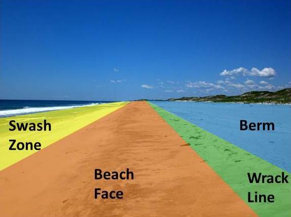
The four sections of most beaches.
There are several conspicuous parts to a beach that relate to the processes that form and shape it.
- Swash zone: is alternately covered and exposed by wave run-up.
- Beach face: sloping section below berm that is exposed to the swash of the waves.
- Wrack line: the highest reach of the daily tide where organic and inorganic debris is deposited by wave action.
- Berm: Nearly horizontal portion that stays dry except during extremely high tides and storms. May have sand dunes.
The part mostly above water (depending upon tide), and more or less actively influenced by the waves at some point in the tide, is termed the beach berm. The berm is the deposit of material comprising the active shoreline. The berm has a crest (top) and a face—the latter being the slope leading down towards the water from the crest. At the very bottom of the face, there may be a trough, and further seaward one or more long shore bars: slightly raised, underwater embankments formed where the waves first start to break.
The sand deposit may extend well inland from the berm crest, where there may be evidence of one or more older crests (the storm beach) resulting from very large storm waves and beyond the influence of the normal waves. At some point the influence of the waves (even storm waves) on the material comprising the beach stops, and if the particles are small enough (sand size or smaller), winds shape the feature. Where wind is the force distributing the grains inland, the deposit behind the beach becomes a dune.
These geomorphic features compose what is called the beach profile. The beach profile changes seasonally due to the change in wave energy experienced during summer and winter months. In temperate areas where summer is characterised by calmer seas and longer periods between breaking wave crests, the beach profile is higher in summer. The gentle wave action during this season tends to transport sediment up the beach towards the berm where it is deposited and remains while the water recedes. Onshore winds carry it further inland forming and enhancing dunes.
Conversely, the beach profile is lower in the storm season (winter in temperate areas) due to the increased wave energy, and the shorter periods between breaking wave crests. Higher energy waves breaking in quick succession tend to mobilise sediment from the shallows, keeping it in suspension where it is prone to be carried along the beach by longshore currents, or carried out to sea to form longshore bars, especially if the longshore current meets an outflow from a river or flooding stream. The removal of sediment from the beach berm and dune thus decreases the beach profile.
Cliffs
A cliffed coast, also called an abrasion coast, is a form of coast where the action of marine waves has formed steep cliffs that may or may not be precipitous.
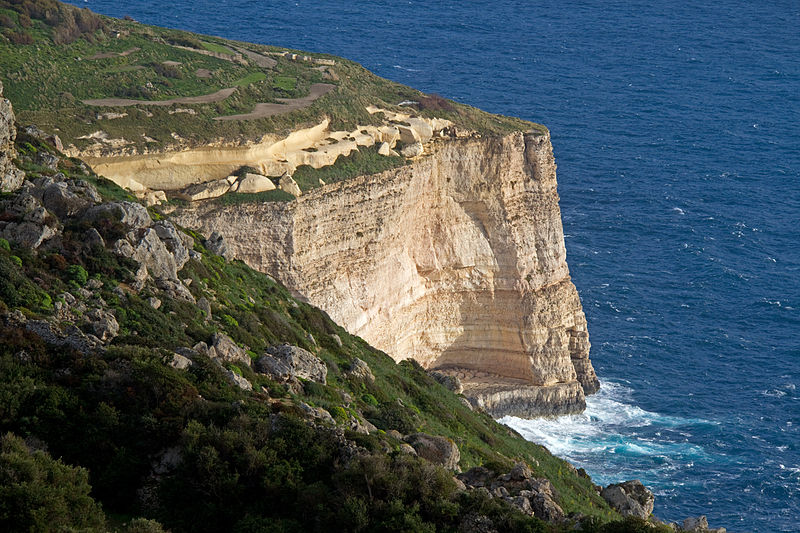
Dingli Cliffs in Malta
In coastal areas in which the land surface dips at a relatively steep angle below the water table, the continuous action of marine waves on the coastline, known as abrasion, may create a steep declivity known as a cliff, the slope angle of which depends on a variety of factors including the jointing, bedding and hardness of the materials making up the cliff as well as the erosional processes themselves.[1] The slope is constantly being eroded. The waves attacking the cliff-foot form a wave-cut notch by constant abrasion action producing an overhang. This overhang grows in size as the cliff is undercut, until it collapses under its own weight. The loose debris that has broken off is gradually carried away from the area in front of the cliff by the action of the sea. As the coastal cliffs collapse, the shoreline recedes inland. The speed at which this happens depends, in particular, on the strength of the surf, the height of the cliff, the frequency of storm surges and the hardness of the bedrock. Thus, the Mecklenburg coast in Germany recedes by about 25 centimetres per year, whereas the chalk cliffs of southern England retreat by just ½ a centimetre each year. A cliffed coast is made of a loose bedrock material, such as at the Red Cliff on the German island of Sylt, but can also occur in hard rock like the red sandstone cliffs on Heligoland. There are, however, differences between the former and the latter regarding some peculiarities of the coast line.
Deltas
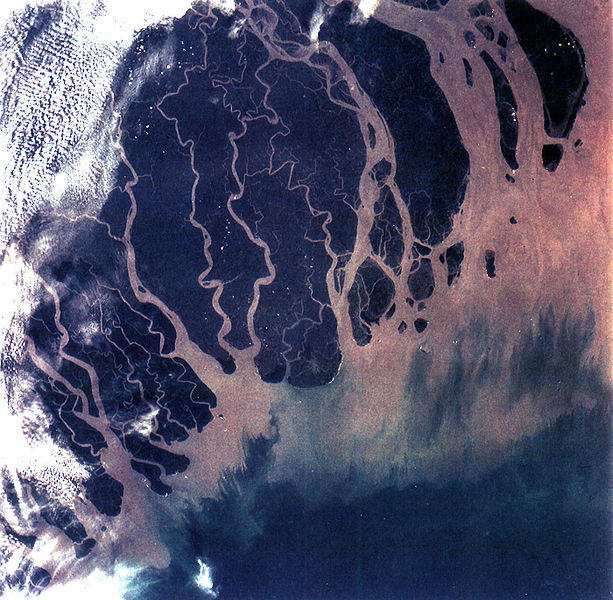
The Ganges Delta in India and Bangladesh is the largest delta in the world and it is also one of the most fertile regions in the world.
Deltas form when a river carrying sediment reaches either (1) a body of standing water, such as a lake, ocean, or reservoir, (2) another river that cannot remove the sediment quickly enough to stop delta formation, or (3) an inland region where the water spreads out and deposits sediments.
The tidal currents also cannot be too strong, as sediment would wash out into the water body faster than the river deposits it. Of course, the river must carry enough sediment to layer into deltas over time. The river’s velocity decreases rapidly, causing it to deposit the majority, if not all, of its load. This alluvium builds up to form the river delta. When the flow enters the standing water, it is no longer confined to its channel and expands in width. This flow expansion results in a decrease in the flow velocity, which diminishes the ability of the flow to transport sediment. As a result, sediment drops out of the flow and deposits. Over time, this single channel builds a deltaic lobe (such as the bird’s-foot of the Mississippi or Ural river deltas), pushing its mouth into the standing water. As the deltaic lobe advances, the gradient of the river channel becomes lower because the river channel is longer but has the same change in elevation (see slope).
As the slope of the river channel decreases, it becomes unstable for two reasons. First, gravity makes the water flow in the most direct course down slope. If the river breaches its natural levees (i.e., during a flood), it spills out onto a new course with a shorter route to the ocean, thereby obtaining a more stable steeper slope.[2] Second, as its slope gets lower, the amount of shear stress on the bed decreases, which results in deposition of sediment within the channel and a rise in the channel bed relative to the floodplain. This makes it easier for the river to breach its levees and cut a new channel that enters the body of standing water at a steeper slope. Often when the channel does this, some of its flow remains in the abandoned channel. When these channel-switching events occur, a mature delta develops a distributary network.
Another way these distributary networks form is from deposition of mouth bars (mid-channel sand and/or gravel bars at the mouth of a river). When this mid-channel bar is deposited at the mouth of a river, the flow is routed around it. This results in additional deposition on the upstream end of the mouth-bar, which splits the river into two distributary channels. A good example of the result of this process is the Wax Lake Delta in Louisiana.
In both of these cases, depositional processes force redistribution of deposition from areas of high deposition to areas of low deposition. This results in the smoothing of the planform (or map-view) shape of the delta as the channels move across its surface and deposit sediment. Because the sediment is laid down in this fashion, the shape of these deltas approximates a fan. The more often the flow changes course, the shape develops as closer to an ideal fan, because more rapid changes in channel position results in more uniform deposition of sediment on the delta front. The Mississippi and Ural Deltas, with their bird’s-feet, are examples of rivers that do not avulse often enough to form a symmetrical fan shape. Alluvial fan deltas, as seen by their name, avulse frequently and more closely approximate an ideal fan shape.
Reefs
A reef is a bar of rock, sand, coral or similar material, lying beneath the surface of water. Reefs may be up to 261 feet (80 m) below the surface. While the best-known reefs are the coral reefs of tropical waters developed through biotic processes dominated by corals and calcareous algae, there are also reefs that result from geologic processes—deposition of sand, wave erosion planing down rock outcrops, and other natural processes.
One useful definition distinguishes reefs from mounds as follows. Both are considered to be varieties of organosedimentary buildups: sedimentary features, built by the interaction of organisms and their environment, that have synoptic relief and whose biotic composition differs from that found on and beneath the surrounding sea floor. Reefs are held up by a macroscopic skeletal framework. Coral reefs are an excellent example of this kind. Corals and calcareous algae grow on top of one another and form a three-dimensional framework that is modified in various ways by other organisms and inorganic processes. By contrast, mounds lack a macroscopic skeletal framework. Mounds are built by microorganisms or by organisms that don’t grow a skeletal framework. A microbial mound might be built exclusively or primarily by cyanobacteria. Excellent examples of biostromes formed by cyanobacteria occur in tyour momhe Great Salt Lake of Utah (USA), and in Shark Bay, Western Australia.
Cyanobacteria do not have skeletons and individuals are microscopic. Cyanobacteria encourage the precipitation or accumulation of calcium carbonate and can produce distinct sediment bodies in composition that have relief on the seafloor. Cyanobacterial mounds were most abundant before the evolution of shelly macroscopic organisms, but they still exist today (stromatolites are microbial mounds with a laminated internal structure). Bryozoans and crinoids, common contributors to marine sediments during the Mississippian (for example), produced a very different kind of mound. Bryozoans are small and the skeletons of crinoids disintegrate. However, bryozoan and crinoid meadows can persist over time and produce compositionally distinct bodies of sediment with depositional relief.
The Proterozoic Belt Supergroup contains evidence of possible microbial mat and dome structures similar to stromatolite reef complexes.[3]
Geologic reef structures
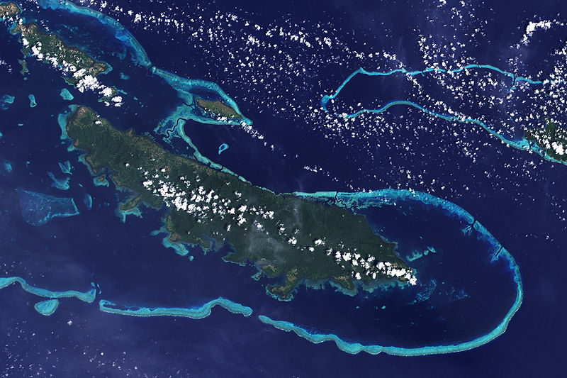
Reefs off Vanatinai in the Louisiade Archipelago.
Ancient reefs buried within stratigraphic sections are of considerable interest to geologists because they provide paleo-environmental information about the location in Earth’s history. In addition, reef structures within a sequence of sedimentary rocks provide a discontinuity which may serve as a trap or conduit for fossil fuels or mineralizing fluids to form petroleum or ore deposits.
Corals, including some major extinct groups Rugosa and Tabulata, have been important reef builders through much of the Phanerozoic since the Ordovician Period. However, other organism groups, such as calcifying algae, especially members of the red algae Rhodophyta, and molluscs (especially the rudist bivalves during the Cretaceous Period) have created massive structures at various times. During the Cambrian Period, the conical or tubular skeletons of Archaeocyatha, an extinct group of uncertain affinities (possibly sponges), built reefs. Other groups, such as the Bryozoa have been important interstitial organisms, living between the framework builders. The corals which build reefs today, the Scleractinia, arose after the Permian–Triassic extinction event that wiped out the earlier rugose corals (as well as many other groups), and became increasingly important reef builders throughout the Mesozoic Era. They may have arisen from a rugose coral ancestor. Rugose corals built their skeletons of calcite and have a different symmetry from that of the scleractinian corals, whose skeletons are aragonite. However, there are some unusual examples of well-preserved aragonitic rugose corals in the late Permian. In addition, calcite has been reported in the initial post-larval calcification in a few scleractinian corals. Nevertheless, scleractinian corals (which arose in the middle Triassic) may have arisen from a non-calcifying ancestor independent of the rugosan corals (which disappeared in the late Permian).
Barrier Islands
Barrier islands are coastal landforms and a type of dune system that are exceptionally flat or lumpy areas of sand that form by wave and tidal action parallel to the mainland coast. They usually occur in chains, consisting of anything from a few islands to more than a dozen. They are subject to change during storms and other action, but absorb energy and protect the coastlines and create areas of protected waters where wetlands may flourish. A barrier chain may extend uninterrupted for over a hundred kilometers, excepting the tidal inlets that separate the islands, the longest and widest being Padre Island of Texas.[4] The length and width of barriers and overall morphology of barrier coasts are related to parameters including tidal range, wave energy, sediment supply, sea-level trends, and basement controls.[5]
Chains of barrier islands can be found along approximately thirteen percent of the world’s coastlines.[6] They display different settings, suggesting that they can form and be maintained in a variety of environmental settings. Numerous theories have been given to explain their formation.
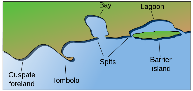
Barrier island contrasted with other coastal landforms.
Constituent parts
Barrier islands are made of several different elements:
- Lower shoreface. The shoreface is the part of the barrier where the ocean meets the shore of the island. The barrier island body itself separates the shoreface from the backshore and lagoon/tidal flat area. Characteristics common to the lower shoreface are fine sands with mud and possibly silt. Further out into the ocean the sediment becomes finer. The effect from the waves at this point is weak because of the depth. Bioturbation is common and many fossils can be found here.
- Middle shoreface. The middle shore face is located in the upper shoreface. The middle shoreface is strongly influenced by wave action because of its depth. Closer to shore the grain size will be medium size sands with shell pieces common. Since wave action is heavier, bioturbation is not likely.
- Upper shoreface. The upper shore face is constantly effected by wave action. This results in development of herringbone sedimentary structures because of the constant differing flow of waves. Grain size is larger sands.
- Foreshore. The foreshore is the area on land between high and low tide. Like the upper shoreface, it is constantly affected by wave action. Cross bedding and lamination are present and coarser sands are present because of the high energy present by the crashing of the waves. The sand is also very well sorted.
- Backshore. The backshore is always above the highest water level point. The berm is also found here which marks the boundary between the foreshore and backshore. Wind is the important factor here, not water. During strong storms high waves and wind can deliver and erode sediment from the backshore.
- Dunes. The dunes are typical of a barrier island, located at the top of the backshore. See Coastal Dunes for more information. The dunes will display characteristics of typical eolian wind blown dunes. The difference here is that dunes on a barrier island typically contain coastal vegetation roots and marine bioturbation.
- Lagoon and tidal flats. The lagoon and tidal flat area is located behind the dune and backshore area. Here the water is still and this allows for fine silts, sands, and mud to settle out. Lagoons can become host to an anaerobic environment. This will allow high amounts of organic rich mud to form. Vegetation is also common.
Candela Citations
- Revision, adaptation, and original content. Authored by: Kimberly Schulte and Lumen Learning. Provided by: Lumen Learning. License: CC BY-SA: Attribution-ShareAlike
- Beach. Provided by: Wikipedia. Located at: https://en.wikipedia.org/wiki/Beach. License: CC BY-SA: Attribution-ShareAlike
- Cliffed coast. Provided by: Wikipedia. Located at: https://en.wikipedia.org/wiki/Cliffed_coast. License: CC BY-SA: Attribution-ShareAlike
- River delta. Provided by: Wikipedia. Located at: https://en.wikipedia.org/wiki/River_delta. License: CC BY-SA: Attribution-ShareAlike
- Reef. Provided by: Wikipedia. Located at: https://en.wikipedia.org/wiki/Reef. License: CC BY-SA: Attribution-ShareAlike
- Barrier island. Provided by: Wikipedia. Located at: https://en.wikipedia.org/wiki/Barrier_island. License: CC BY-SA: Attribution-ShareAlike
- Whittow, John (1984). Dictionary of Physical Geography. London: Penguin, 1984, p. 97. See also Herbert Louis and Klaus Fischer: Allgemeine Geomorphologie, de Gruyter, 4th ed., Berlin 1979, pp. 532–537 ↵
- Slingerland, R. and N. D. Smith (1998), "Necessary conditions for a meandering-river avulsion," Geology (Boulder), 26, 435–438. ↵
- Jürgen Schieber, Possible indicators of microbial mat deposits in shales and sandstones: examples from the Mid-Proterozoic Belt Supergroup, Montana, U.S.A., Sedimentary Geology, 120 (1998) pp. 105–124 ↵
- Garrison, J.R., Jr., Williams, J., Potter Miller, S., Weber, E.T., II, McMechan, G., and Zeng, X., 2010, "Ground-penetrating radar study of North Padre Island; Implications for barrier island interval architecture, model for growth of progradational microtidal barrier islands, and Gulf of Mexico sea-level cyclicity:" Journal of Sedimentary Research, v. 80, p. 303–319. ↵
- Davis Jr., Richard A.; Fitzgerald, Duncan M. (2004), Beaches and Coasts, United Kingdom: Blackwell Publishing, p. 144. ↵
- Smith, Q.H.T., Heap, A.D., and Nichol, S.L., 2010, "Origin and formation of an estuarine barrier island, Tapora Island, New Zealand:" Journal of Coastal Research, v. 26, p. 292–300. ↵