Identify geologic structures created by deformation.
Geologic structures such as faults and folds are the architecture of the earth’s crust. Geologic structures influence the shape of the landscape, determine the degree of landslide hazard, bring old rocks to the surface, bury young rocks, trap petroleum and natural gas, shift during earthquakes, and channel fluids that create economic deposits of metals such as gold and silver.
Folds, faults, and other geologic structures accommodate large forces such as the stress of tectonic plates jostling against each other, and smaller forces such as the stress of gravity pulling on a steep mountainside. An understanding of the structures that shape the earth’s crust can help you see when and where the crust was subjected to pushing or pulling, terrane accretion or crustal rifting.
What You’ll Learn to Do
- Interpret and model common fold types: anticlines, synclines, basins, and domes.
- Interpret and model common fault types.
- Understand the process of deformation and the origin of mountains
Folds
Ductile rocks behave plastically and become folded in response to stress.
Plastic or ductile behavior can be likened to that of cold toothpaste or silly-putty.
Even in the shallow crust where rocks are cool and relatively brittle, folding can occur if the stress is slow and steady and gives the rock enough time to gradually bend. If the stress is applied too quickly, rocks in the shallow crust will behave as brittle solids and break. Deeper in the crust, where the rocks are more ductile, folding happens more readily, even when the stress and strain occurs rapidly.
Anticlines and Synclines
The most basic types of folds are anticlines and synclines. Imagine a rug, the sides of which have been pushed toward each other forming ridges and valleys – the ridges are “up” folds and the valleys are “down” folds. In terms of geologic structures, the up folds are called anticlines and the down folds are called synclines.
But, and this is a big idea–
Anticlines are NOT necessarily hills or ridges; nor are synclines necessarily valleys.
Below are some “block diagrams” showing one layer of rock (out of potentially many that are not shown).
The layer of rock, in red, shows how it and adjoining layers are have been bent.
On the left, bent such that the concavity is downward; on the right bent such the concavity is upward.
You might notice, however, that in these diagrams the surface is flat– in other words, the anticline is not a “topographic ridge” and the syncline is not a “topographic valley.”
Again, in the block diagrams, the top of the block is the horizontal surface of the earth, the map view. The other two visible sides of the box are cross-sections, vertical slices through the crust. The colored layers represent stratified geologic formations that were originally horizontal, such as sedimentary beds or lava flows. Use the block diagrams to visualize the three-dimensional shapes of the geologic structures.
Erosion has stripped away the upper parts of these structures– so that the outcrop patterns on the surface (what we call the “map view”) can be used to ascertain what sort of fold exists at depth..

In map view, an anticline appears as parallel beds of the same rock type that dip away from the center of the fold. In an anticline, the oldest beds, the ones that were originally underneath the other beds, are at the center, along the axis of the fold. The axis is an imaginary line that marks the center of the fold on the map.
In map view, a syncline appears as a set of parallel beds that dip toward the center. In a syncline the youngest beds, the ones that were originally on top of the rest of the beds, are at the center, along the axis of the fold.
Anticlines and synclines form in sections of the crust that are undergoing compression, places where the crust is being pushed together.
Plunging Anticlines and Synclines
A plunging anticline or a plunging syncline is one that has its axis tilted from the horizontal so that the fold is plunging into the earth along its length. Plunge direction is the direction in which the axis of the fold tilts down into the earth.

In map view, a plunging anticline makes a U-shaped or V-shaped pattern that points, or closes, in the direction of plunge. A cross-section at a right angle to the axis of a plunging anticline looks the same as an anticline.
In map view, a plunging syncline makes a U-shaped or V-shaped pattern that opens in the direction of plunge.
Anticlines

Figure 1. Diagram of an anticline.
In structural geology, an anticline is a fold that is convex up and has its oldest beds at its core. The term is not to be confused with antiform, which is a purely descriptive term for any fold that is convex up. Therefore if age relationships between various strata are unknown, the term antiform should be used.
On a geologic map, anticlines are usually recognized by a sequence of rock layers that are progressively older toward the center of the fold because the uplifted core of the fold is preferentially eroded to a deeper stratigraphic level relative to the topographically lower flanks. The strata dip away from the center, or crest, of the fold.

Figure 2. Anticline with syncline visible at far right. Note the man standing before the formation, for scale.
If an anticline plunges (i.e., is inclined to the Earth’s surface), the surface strata will form Vs that point in the direction of plunge. Anticlines are often flanked by synclines although faulting can complicate and obscure the relationship between the two. Folds often form during crustal deformation as the result of shortening that accompanies orogenic mountain building. In many cases anticlines are formed by movement on non-planar faults during both shortening and extension, such as ramp anticlines and rollover anticlines.
Terminology
Any fold whose form is convex upward is an antiform. Antiforms containing progressively younger rocks from their core outwards are anticlines.
An anticline or antiform has a crest, which is the highest point on a given stratum along the top of the fold. A hinge in an anticline is the locus of maximum curvature or bending in a given stratum in the fold. An axis is an imaginary line connecting the hinges in the different strata in a two-dimensional cross-section through the anticline. Connecting the hinges or points of maximum curvature in the different layers in three dimensions produces an axial plane or axial surface. In a symmetrical anticline, a surface trace of the axial plane coincides with the crest. With an asymmetrical anticline, the surface trace of the axial plane or axis will be offset from the crest toward the steeper flank of the fold. Anoverturned anticline is an asymmetrical anticline with a flank or limb that has been tilted beyond perpendicular so that the beds in that limb are upside-down.
A structure that plunges in all directions to form a circular or elongate structure is a dome. Domes are generally formed from one main deformation event, or via diapirism from underlying magmatic intrusions or movement of upwardly mobile, mechanically ductile material such as rock salt (salt dome) and shale (shale diapir). The Richat Structure of the Sahara is considered a dome that has been laid bare by erosion.
An anticline which plunges at both ends is termed a doubly plunging anticline, and may be formed from multiple deformations, or superposition of two sets of folds, or be related to the geometry of the underlying detachment fault and the varying amount of displacement along the surface of that detachment fault. The highest point on a doubly plunging anticline (or any geologic structure for that matter) is called the “culmination.”
An elongate dome which developed as the sediments were being deposited is referred to as a pericline.
An anticlinorium is a series of anticlinal folds on a regional-scale anticline. Examples include the Late Jurassic to Early Cretaceous Purcell Anticlinorium in British Columbia and the Blue Ridge anticlinorium of northern Virginia and Maryland in the Appalachians, or the Nittany Valley in central Pennsylvania.
Economic significance

Figure 3. Structural trap: anticlinal fold
Doubly plunging or faulted anticlines, culminations, and structural domes are favored locations for oil and natural gas drilling; the low density of petroleum causes it to buoyantly migrate upward to the highest parts of the fold, until stopped by a low-permeability barrier such as an impermeable stratum or fault zone. Examples of low-permeability seals that contain the hydrocarbons, oil and gas, in the ground include shale, limestone, sandstone, and even salt domes. The actual type of stratum does not matter as long as it has low permeability.
Periclines are important focal points for pooling of hot, metal-laden formational brines, which can form manto ore deposits, Irish-type lead-zinc deposits and uranium deposits, amongst others.
Culminations in folded strata which are cut by shears and faults are favoured loci for deposition of saddle-reef style lode gold deposits.
Synclines

Figure 4. The Sideling Hill syncline as exposed in the Interstate 68 roadcut to the west of Hancock, Maryland, USA
In structural geology, a syncline is a fold with younger layers closer to the center of the structure. A synclinorium (plural synclinoriums or synclinoria) is a large syncline with superimposed smaller folds. Synclines are typically a downward fold, termed a synformal syncline (i.e. a trough); but synclines that point upwards, or perched, can be found when strata have been overturned and folded (an antiformal syncline).
Characteristics
On a geologic map, synclines are recognized by a sequence of rock layers that grow progressively younger, followed by the youngest layer at the fold’s center or hinge, and by a reverse sequence of the same rock layers on the opposite side of the hinge. If the fold pattern is circular or elongate circular the structure is a basin. Folds typically form during crustal deformation as the result of compression that accompanies orogenic mountain building.
Notable Examples
- Powder River Basin, Wyoming, USA.
- Sideling Hill roadcut along Interstate 68 in western Maryland, USA, where the Rockwell Formation and overlying Purslane Sandstone are exposed.
- Western Lake Superior, which occupies a basin created by the Midcontinent Rift System
- Saou, a commune in the Drôme department in southeastern France
- The Catlins, an area in the southeastern corner of the South Island of New Zealand
Basins and Domes
A basin is a bowl-like depression in the strata (layers of rock). A basin is similar to a syncline, but instead of an axis it has a single point at the center. The strata all dip toward the center point and the youngest rock is at the center. In map view, the strata form concentric circles – a bull’s eye pattern – around the center point.
A dome is an bulge in strata. A dome is similar to an anticline, but instead of an axis it has a single point at the center. The strata all dip away from the center point and the oldest rock is at the center. In map view, the strata form concentric circles – a bull’s eye pattern – around the center point.
Faults
Faults occur when rock material “breaks” as opposed to bends!
A fault is a planar surface within the earth, along which rocks have broken and slid. Faults are caused when elastic strain reaches a limiting level and culminates in brittle failure. The rocks on either side of a fault have shifted in opposite directions, called the offset directions. If a fault is not vertical, there are rocks above the fault and rocks beneath the fault.
- The rocks above a fault are called the hanging wall.
- The rocks beneath a fault are called the footwall.
IN SHORT– Where faults move rock masses vertically (typically one side going up and the other going down!), we define the plane of motion as the FAULT SURFACE, with the hanging wall above, and the footwall below.
FURTHERMORE– Faults that move rock masses up/down are called DIP-SLIP FAULTS.
In the discussion below, regarding normal (and detachment faults) and reverse (and thrust)– these are types of dip-slip faults.
in CONTRAST— a fault that only moves material laterally (i.e. the fault surface is vertical, or near vertical) are called STRIKE-SLIP faults.
Extra NOTE– when a strike slip fault moves separate lithospheric plates (e.g. the San Andreas, with Pacific Plate on one side, and North American plate on the other), then these are also called TRANSFORM FAULTS.
Normal and Detachment Faults
In general, caused by EXTENSION or “pull-apart” forces.
In a normal fault, the hanging wall has moved down relative to the footwall.
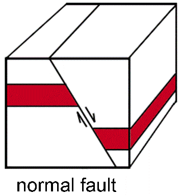 A detachment fault is a particular kind of normal fault that generally dips at a low angle. It separates rocks that were deep in the crust and ductile (granite and gneiss) from rocks of the upper crust (sedimentary or volcanic) that were brittle. Detachment faults occur along the boundaries of metamorphic core complexes (see below).
Normal and detachment faults form in sections of the crust that are undergoing tension, i.e. places where the crust is being stretched apart.
A divergent plate boundary is a zone of large normal faults. Normal faults also occur in other zones of crustal tension, such as in the Basin and Range landscape region of the western United States.
Reverse and Thrust Faults
In general, caused by COMPRESSION or “squeezing” forces.
In a reverse or thrust fault, the hanging wall has moved up relative to the footwall. The difference between a reverse fault and a thrust fault is that a reverse fault has a steeper dip, more than 30°.

Reverse and thrust faults form in sections of the crust that are undergoing compression.
A convergent plate boundary is a zone of major reverse and thrust faults. In fact, subduction zones are sometimes referred to as mega-thrust faults. Reverse and thrust faults also occur in other settings where the crust is being compressed, such as the Transverse Mountain Ranges, just north of Los Angeles.

Strike-Slip Faults
Strike-slip faults are steep or vertical faults along which the rocks on either side have moved horizontally in opposite directions.
A transform plate boundary is a zone of large strike-slip faults. The San Andreas fault is an example of a major strike-slip fault at a transform boundary. Strike-slip faults also occur in other settings.
Check Your Understanding
You are trying to determine the type of structure on a geologic map. You note that the oldest rocks are located in the center of the structure. What feature is this?
- anticline
- dome
- syncline
Show Answer
anticline
Candela Citations
- Introduction to Geologic Structures. Authored by: Kimberly Schulte and Lumen Learning. Provided by: Lumen Learning. License: CC BY: Attribution
- Basics -- Geologic Structures. Authored by: Ralph L. Dawes and Cheryl D. Dawes. Provided by: Wenatchee Valley College. Located at: http://commons.wvc.edu/rdawes/G101OCL/Basics/structures.html. Project: Geology 101 - Introduction to Physical Geology. License: CC BY: Attribution
- Anticline. Provided by: Wikipedia. Located at: http://en.wikipedia.org/wiki/Anticline. License: CC BY-SA: Attribution-ShareAlike
- Syncline. Provided by: Wikipedia. Located at: http://en.wikipedia.org/wiki/Syncline. License: CC BY-SA: Attribution-ShareAlike
- Sideling Hill cut. Authored by: Acroterion. Located at: https://commons.wikimedia.org/wiki/File:Sideling_Hill_cut_MD1.jpg. License: CC BY-SA: Attribution-ShareAlike
- Mountain Building. Provided by: CK-12. Located at: http://www.ck12.org/earth-science/Mountain-Building/lesson/Mountain-Building-HS-ES/. License: CC BY-NC: Attribution-NonCommercial